
A Lincoln Highway Driving Tour Through Bedford County
Travel Time: 4-8 hours (depending on how much time is spent at each location)
Travel Distance: Approximately 45 miles
- Start your drive along Route 30 in the westernmost part of Bedford County, heading east. On the right, going downhill you’ll see a pull-off with the remnants of a wall looking out over a beautiful mountain vista. This is GRAND VIEW POINT. This scenic location was once the GRAND VIEW SHIP HOTEL which, from 1932-1970s, boasted itself the Grand Ship of the Alleghenies. From its decks you could see three states (Pennsylvania, Maryland, and West Virginia) and seven counties. The hotel eventually fell into disrepair and burned down in 2001.
- At the hairpin curve below Grand View Point sits the OLD SHOT FACTORY. During the Revolutionary War, cannon shot was manufactured by dropping lead from the second story.
- About 5 miles ahead is the BISON CORRAL. Look to your left for the mural painted on the barn and to see the bison roaming in the pastures.
- Just east of the bison farm on the right, look carefully to see the blue cabins hiding behind overgrown bushes. Once part of the SHAWNEE CABINS TOURIST CAMP, they now house seasonal farm workers.
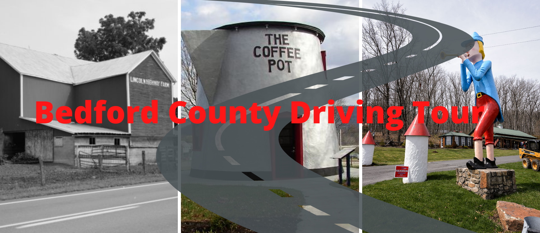
- Ahead on the left is the LINCOLN HIGHWAY FARM, painted on the two red barns. This farm has been owned by the same family for over 150 years.
- About 0.5 mile east of the farm, turn right onto Cemetery Road to follow the old Lincoln Highway. The 1806 OLD LOG CHURCH, a preserved log church, still has its original straight-back wooden pews and wine glass pulpit.
- Before turning to rejoin Route 30, glance to your left to see a giant statue of the PIED PIPER blowing his horn. Since the 1950s he has guarded the entrance to Storyland, a former children’s park that has been closed since the 1980s.
- Ahead is the BOROUGH OF SCHELLSBURG, a National Register Historic District (1810).
- Next is GRAVITY HILL, Turn North onto Route 96 towards New Paris. Drive about 3.8 miles and turn left onto Bethel Hollow Road. Drive for 0.6 mile and bear left at the “Y” in the road. After another 1.5 miles you will come upon an intersection that has a stop sign (for oncoming traffic only). Bear right onto this road and drive 0.2 mile, looking for the letters”GH” spray painted on the road. Go past the first “GH” letters to the second painted “GH”. You have arrived. This is where cars roll uphill.
- Turn around and return back to Route 30 in Schellsburg. Turn right onto Route 30 west. Drive one block and take the first left at the Colvin Covered Bridge sign (Mill Road). Drive 0.8 mile down this road. The COLVIN COVERED BRIDGE was built in 1866 and refurbished in 1997. Return back to Route 30 and turn east to continue.
- Go about 1 mile past Schellsburg and turn right into SHAWNEE STATE PARK. Follow the signs and explore some of the 3,983 acres of this scenic ridge and valley province. A focal point of the park is the 451 acre Shawnee Lake. After enjoying the park return to Route 30 and turn right (east).
- To follow the original Lincoln Highway, turn left onto Shawnee Sleepy Hollow Road. Here you will pass a former tavern house made of log and stone (1775) on the left that is now owned by the SHAWNEE SLEEPY HOLLOW CAMPGROUND. At the stop sign, turn left to rejoin Route 30 east.
- At the crest of the hill, on the right is the LINCOLN MOTOR COURT, featuring cabins that were refurbished to their original 1930s look.
- At the intersection of Routes 30 and 31 sits the historic JEAN BONNET TAVERN. The tavern was built in 1769 at the fork where the 1758 Forbes Road diverged from the 1755 Burd Road. About 100 yards beyond the tavern is a concrete Lincoln Highway marker on your left. (NOTE: To follow the original Lincoln, about 1.3 miles ahead, turn right onto Wolfsburg Road. Turn right at the traffic light to rejoin Route 30.)
- As you approach Bedford, bear right and follow the business district route. As you approach town, the Bedford County Fairgrounds will be to the right. The 1927 COFFEE POT was rescued and moved to this site in 2004. This building is an excellent example of early automobile era architecture designed to attract customers with the novelty of the setting.
- Continuing on Business Route 30 becomes Pitt Street. On your right is the art deco-style DUNKLE’S GULF SERVICE STATION. Opened in 1933, the station's terracotta tiles depict stylized geometric foliage and chevrons. (NOTE: You can visit the Bedford County Visitors Bureau by turning right at the intersection of Pitt and Juliana streets. It’s halfway down the block on the left.)
- Continuing on Pitt Street, the 1766 ESPY HOUSE, on your left. Designated as a National Historic Landmark, this house served as President Washington’s headquarters during the Whiskey Rebellion in 1794.
- Several blocks ahead, as you’re leaving Bedford, Pitt Street ends at a stop sign. Turn left. Ahead, you’ll be traveling over the Raystown Branch of the Juniata river. Drive about 8 miles.
- From Route 30, take the Everett exit (Route 26S Exit) to travel the old Lincoln Highway through Everett.
- On your left, just before Hometown Bank, is another concrete Lincoln Highway marker. Continuing ahead and beyond the first light, watch on your left for the Everett mural and immediately to your right the 1898 UNION HOTEL. which several years ago underwent an extensive restoration.
- On the way out of town you will pass the IGLOO ICE CREAM PARLOR on your right, painted to resemble a scoop of ice cream.
- Just beyond is one of the Lincoln Highway Heritage Corridor’s Roadside Giants: a GIANT QUARTER with George Washington’s profile. This is located at the entrance of the Down River Golf Course. At the traffic light, turn right to rejoin Route 30 East.
- Ahead on the right is the former JUNIATA CROSSINGS LODGE. Now an interior design store, it was built as a stagecoach stop in the early 1800s.
- Just before you reach Breezewood on the right is the recently renovated 1788 INN. This bed & breakfast was an 18th century tavern and stagecoach stop. Today visitors can stay in one of the four guest rooms to experience the history of the building.
- Ahead is the “Town of Motels,” or Breezewood. It was just a small town until the PA Turnpike opened in 1940 with an interchange here. Businesses servicing the traffic along the turnpike have thrived here ever since.
- NOTE: The 1-mile commercial strip is usually congested, so drive cautiously. Stay in the lane marked Route 30 E to continue following the Lincoln Highway.
- Ahead on the left is the GATEWAY TRAVEL PLAZA, built in 1994 to replace the original one owned by Merle and Marion Snyder in 1940. The Snyders often traded a meal or gasoline for a soldier’s patch. This interesting collection that they accumulated over the years is still on display at the facility. While here you can catch a meal at one of many restaurants to relax after your tour.